

|
|
Coordinators :
Kiyoshi Igarashi
Upper Atmosphere Section,
Space Science Division,
CRL, Tokyo, Japan
email : igarashi@ctl.go.jp
Web: http://hiraiso.crl.go.jp/wdc-c2/kokubunj.html
Bodo Reinisch
University of Massachusetts Lowell
Center for Atmospheric Research
Lowell, MA, USA
email : Bodo_Reinisch@uml.edu
Web: https://ulcar.uml.edu/
The Pacific Region Equatorial Anomaly Studies in Asia (PREASA) program is designed to investigate the dynamics and coupling of the middle altitude atmosphere, the high and middle latitude ionosphere to the ionospheric regions controlled by the equatorial anomaly phenomena. The equatorial anomaly phenomena covers a region from the magnetic equator to 30o geomagnetic latitude in each hemisphere. The anomaly regions are of importance due to their connection with the equatorial ionosphere, and their location as the latitudinal transition region from low latitudes into the tropical and mid-latitudes. The electro- and atmospheric dynamics within this region contribute to the formation of instabilities in the ionosphere which form irregularities in the ionization content that cover a large range of scale sizes. These irregularities cause signal deterioration to systems in use by the telecommunications industry in Asia, which covers the spectrum from the large scale irregularities causing Spread-F conditions (dropouts in the signal levels in the HF spectrum) to small-scale irregularities that cause scintillation's (deteriorate the quality of the signals for ground to satellite communications).
The PREASA program supports a community which consists of a wide variety of scientists from institutions in Russia, China, Japan, Taiwan, Korea, Thailand, Indonesia, Australia, Papua New Guinea and USA. PREASA offers communication and analysis procedures to meet the needs of the atmospheric community in the Pacific/Asian region. The effort from this program will help the telecommunications network be better informed as to when problems may arise, and improved understanding of the mechanisms responsible for generation of small-scale irregularities can further help in setting up procedures to compensate for the effects on satellite systems, and ground HF communications. PREASA was established to support the ongoing efforts of the Pan-Pacific Regional Telecommunication Network Experiment and Research by Satellite (PARTNERS) project.
The PREASA program began with the running
of the first PREASA-1 campaign from 22 February to 14 March 1996. Figure
1 displays a map of the station locations in south-east Asia which took
part in PREASA-1. During this campaign the PREASA database was setup at
CRL (Japan) which is extremely important to the comparison efforts and
development of global atmospheric models. This database also allows researchers
in the Asian sector access to a central data depository site were data
can be freely exchanged and maintained to promote collaboration between
the various research institutes in the Asian sector. The interaction of
the modelers and experimentalists will enhance the understanding of the
physics controlling the equatorial anomaly and instability generation mechanisms
in the south-east Asian region. Due to the orientation of the earths magnetic
field, the characteristics of the equatorial anomaly in the south-east
Asian regions are unique and not easily related to measurements made at
other longitudes. As an example many models currently use assumed electric
field patterns that, previous analysis have shown to be, at times, inadequate
in describing the characteristics of the equatorial ionosphere in south-east
Asia. Global models require as a minimum global coverage.
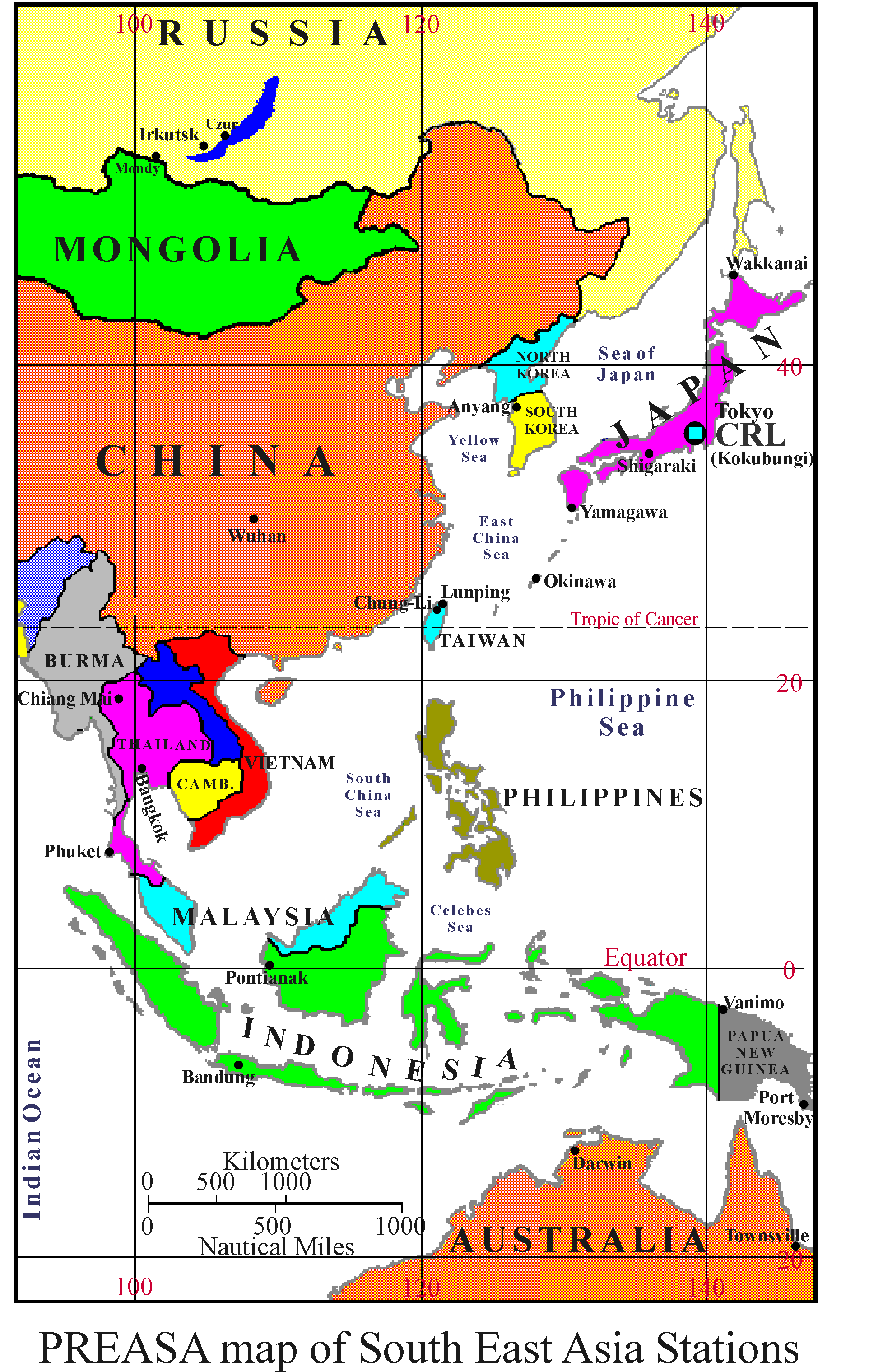
Figure 1
1.1 The Equatorial Anomaly :
Characterized as the occurrence of a trough in the ionization concentration at the equator and crests at about 17o in magnetic latitude [Appleton, 1946] in each hemisphere, the equatorial anomaly has been well described as arising from the electrodynamics at the equator. Tidal oscillations in the lower ionosphere move plasma across the magnetic field lines which are horizontal at the magnetic equator. The resulting E-region dynamo sets up a intense current sheet referred to as the equatorial electrojet. The zonal current flows eastward during the day and westward at night. Since an electric field is established perpendicular to the magnetic field an ExB/B2 drift moves the ionization vertically upwards during the day and downwards at night. The upward motion of ionization during the day is termed the equatorial fountain, since ionization rises above the magnetic equator until pressure forces become appreciable that it slows down and under the force of gravity moves along the field lines and is deposited at higher tropical latitudes. The resulting enhancement of ionization at tropical latitudes and a trough in ionization concentration at the magnetic equator is termed of the equatorial anomaly. Since Martyn [1955] first put down the electrodynamic drift theory, many theoretical investigations have verified that this theory is a plausible explanation of the formation of the equatorial anomaly [Townsend 1982; Kelly 1989; Balan and Bailey 1995 and references therein].
The equatorial anomaly is often not symmetrical about the magnetic equator due to the interaction of the neutral wind. The asymmetry tends to produce the largest peaks in the winter season, since the neutral winds usually cause plasma to be pushed from the summer to the winter hemisphere. Also due to the declination of the earths magnetic field, the characteristics of the anomaly regions differ with longitudes. The anomaly regions in the southeast Asia sector would be unique due to stronger trapping of higher energy particles at a given altitude. D-region absorption would be greater, and even slight geomagnetic disturbances would substantially effect the distribution of ionization in the anomaly regions. A review by Walker [1981] discusses some of the differences observed in the characteristics of the equatorial anomaly in the American, African and East Asian longitudes. One of the main criticisms Walker made was in the difficulty of drawing conclusions from a limited number of ground stations. The PREASA community consists of observatories located in at least six countries near or in the equatorial anomaly, consistently making observations during and after the campaign period. It has been noted by many researchers that additional work in both monitoring and theory of the equatorial anomaly is needed especially in the southeast Asian sector ( Tascione 1988 page 79).
Studies on the equatorial anomaly in the south-east Asian region have been conducted (Walker et al., 1994 and references within). However many of these studies involved statistical analysis which tended to supply general seasonal and diurnal variations in the characteristics of the equatorial anomaly. Yet the mechanisms which trigger many of the instabilities that lead to the formation of irregularities and cause scintillation's are of short duration. Induced electric fields, which cause large altitude variations in the ionospheric layers, the effect of gravity waves, and the daily variability of the equatorial anomaly are generally smoothed out by such statistical methods. Table 1 outlines a summary of the known Equatorial Anomaly Characteristics "EAC" and what needs to be known about the equatorial anomaly region.
Table 1
|
|
|
|
| Daytime ExB
drift at the magnetic equator drives ionization across the earths magnetic
field lines to higher altitudes. The diurnal variation of the vertical
drift has been measured at Jicamarca, Arecibo and successfully modeled
(Fejer et al., 1991, Fejer 1993).
The ExB drift is known to vary with altitude and latitude (Pingee and Fejer 1987). When upward drifting ionization looses its momentum it diffuses under gravity along the magnetic field lines to higher latitudes where it causes an increase in the ionization concentration defined as the equatorial anomaly. The seasonal, diurnal, and latitudinal extent of the equatorial anomaly has been observed. (Walker et al., 1994 and references within). The neutral wind makes the fountain and equatorial anomaly asymmetric with the largest plasma flow towards the hemisphere of polar wind. (Balan and Bailey 1995 and references within). Due to the declination of the magnetic field lines the asymmetry characteristics of the equatorial anomaly in the American, African and East-Asia is different (Walker 1981). Downward compression of ionization due to large downward ExB drift can produce the nighttime increase in Nmax at the equator (Rao 1963). An enhanced downward ExB drift in the pre-sunset period is also responsible for the pre-sunrise F-region collapse (Rastogi 1987). The equatorial anomaly phenomena in the F2 region, has been observed at up to 38o geomagnetic latitude in each hemisphere. The average location of the latitudinal crests in Nmax vary by only 2o to 3o from solar maximum to solar minimum conditions (Klobuchar et al., 1991). |
Evidence exists
that the diurnal variation in the south-east Asian sector can be at times
quite different to the vertical movements observed in the Jicamarca and
Arecibo longitude (Rastogi 1987; Takami et al., 1995). Measurements and
modeling of the vertical velocity over the east/Asian equatorial regions
is necessary.
No measurement of the variation of the ExB drift for the Pacific/Asian region exists. Many studies reported results from hourly or median values. Much of the daily variability of the equatorial anomaly is absorbed by these statistical results. Consequently the physics of the triggering mechanisms for instabilities, and overall dynamics for the east/Asian pacific ionospheric region is still unknown. Higher time resolution observations and analysis is needed. The neutral wind is also modulated by the effects of gravity waves. The resultant traveling ionospheric disturbances effect the characteristics of the equatorial anomaly throughout the day. No understanding of the modulation of the equatorial anomaly exists. An attempt to couple the high, mid-latitude regions with the equatorial anomaly region is necessary. The day to day variability of the pre-sunrise
enhanced downward ExB drift which is a
phenomena observed primarily in the South-East Asian sector, has yet to
be done.
The overall effects on the anomaly and the variability of ionization in the lower latitude regions as observed by ionosonde, and TEC measurements, for various geomagnetic disturbance levels is needed for the south-east Asian sector. |
1.2 Goals and Objectives
The PREASA campaigns are setup to address
some of the unknowns in the characteristics of the equatorial anomaly that
were listed in Table 1. These goals were;
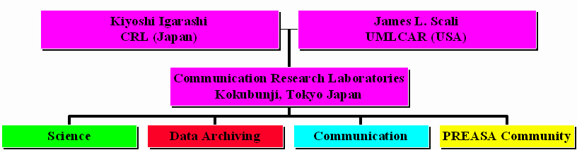
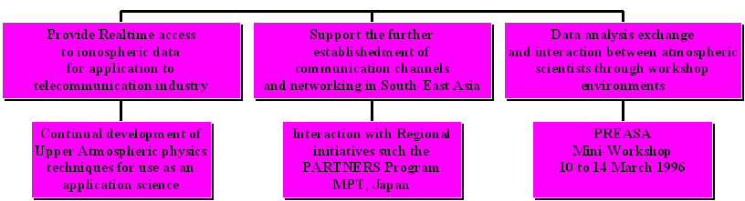
The PREASA Program was established during the first PREASA-1 campaign (22 February to 14 March 1997). Chart 1 specifies the original structure of PREASA and the main objectives of the program. PREASA began with the cooperation between CRL (Japan) and UMLCAR (USA). Both institutions contribute in maintaining and coordinating the program. During the campaign period from 22 Feb. to 14 March 1996 the main architecture for the PREASA program was established at CRL in Kokubunji, Tokyo, Japan. The coordinators in conjunction with personnel at CRL (Japan) addressed four main areas of the PREASA program, these being;
(a) Science issuesWe will discuss each area separately in the following sections.
(b) Database/Data archiving issues
(c) Communication issues
(d) PREASA Community issues
Chart 1 : Original PREASA-1 Structure
3.0 Science issues / Scientific Objectives
PREASA consists of several countries and researchers with interests that cover a wide range of scientific objectives. While the main objective of the campaign related to understanding the equatorial anomaly region, this still leaves a multitude of research interests. To better coordinate the analysis and discussions a smaller subset of working groups was implemented to focus on specific issues. These working groups are;
(a) Middle Atmosphere and Lower Ionosphere Coupling in the Equatorial Anomaly.In chart 2 each working group has a brief list on the left specifying the science issues, while on the right boxes are listed the instruments whose data may best contribute to the analysis. Its important to mention the high time resolution of the instruments in campaign mode which allow tracking of short duration events that could trigger instabilities in the ionosphere.
(b) TEC Measurements in the Equatorial Anomaly.
(c) F-Region studies and the characteristics of the equatorial electric field.
(d) High, Mid-latitude coupling events to the Equatorial anomaly.
Chart 2 PREASA Scientific Working groups
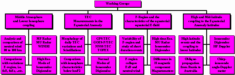
3.1 Specification of working groups and scientific interests.
The following list of working groups and objectives were devised to help participants focus their analysis efforts, the list is by no means final, and will be subject to changes dependent of what new interests are generated by the PREASA community. This list is offered to the community, and the PREASA participants are urged to either put their names to which ever group(s) they feel they have something to contribute and email the information back to the coordinators. The possible working groups consist of:
I Middle atmosphere - Lower ionosphere coupling in the Equatorial anomaly:Results from the MF, MU Radar and WINDII instruments will be compared. A study of the characteristics of the neutral wind in the middle atmosphere over the PREASA campaign period will be produced. Where possible the data will be compared with results from measurements in the lower ionospheric layers, such as the high resolution ionogram CRL data base, and Digisonde profiles. Variations in sporadic E layers will be compared with changes in the middle atmosphere neutral winds. The fine variations of the lower E-F region as observed by the 1 km group range resolution of the CRL ionosondes will be used to observe small fluctuations in these regions and again compared with the neutral wind data. The specific goal is to identify the frequency of occurrences when a clear coupling of the middle atmospheric dynamics is observed in the ionosphere. Not all gravity waves break at 90 km, what are the effects of these waves on the lower ionospheric layers?
II. TEC Measurements in the Equatorial Anomaly
Develop a morphology of TEC daily variations during the PREASA period. What days show the greatest variability? Comparisons with ionosonde data can determine where the largest differences in the ionization content appears. Is the ionization above the F-region peak more sensitive to small variations in the magnetic activity in the anomaly region? This could suggest changes in the ionization being supplied from the equator which may not be obvious in the ionogram records. Are large variations in the lower F-region observed in the TEC measurements? This study should also determine the extent of scintillation effects on the TEC data. When do they most often occur, at which latitudes, how long does the event last? In trying to determine the triggering mechanism for the instabilities it is important that we are able to identify "hot-spots" were scintillation occurs more frequently. Stations which have a Digisonde close by should invest some time in processing the drift data and using the skymap or reflection source location positions try to identify unusual structure in the ionosphere, in the local neighborhood.
III F-Region studies and the characteristics of the equatorial electric field.
Perhaps the most obvious effects of the equatorial ionosphere are contained within the study of the F-region characteristics. This study will focus on the daily variability of the F-region, using the high time resolution of the ionosonde data base to investigate possible sources of instability triggering mechanisms. The study will involve an analysis of the daily variability of the pre-sunrise F-region collapse and relate the observations to the magnetometer data available in the South-east Asian sector. This study must further the understanding of the ExB downward vertical drift observed in this region, identify the latitudinal extent of the ExB effect, and compare these results with known E-field models developed from data generated from Jicamarca. The study should access if the electric field model currently used is accurately representing equatorial electric fields in the south-east Asian regions.
IV High, Mid- Latitude coupling events to the Equatorial anomaly.
This study will investigate the coupling of events observed in the high, to mid-latitudes to the equatorial anomaly regions. Propagation of TIDs from the high latitudes to low latitudes will be identified and analyzed to determine how these phenomena effect the distribution of ions in the equatorial anomaly region. It is known that the trans-equatorial neutral wind causes an asymmetry in the equatorial anomaly in each hemisphere, however the frequency of TIDs observed during the PREASA campaign indicate that these phenomena could add an additional modulation to the normal diurnal variation of the anomaly region. The chain of CRL ionosondes in conjunction with ionosondes in other counties will be used to identify those times when TIDs propagate from high to low latitudes. The oblique propagation studies between Russia and Australia would be important in comparing the observations from ionosondes at these times. The ideology is to identify the background diurnal variation expected in the area and then monitor the effects if TIDs observed over the stations. The PREASA campaign period saw very quiet geomagnetic conditions. The data set is idea for identifying the normal coupling between the mid latitude and lower latitude regions.
4.0 Data Archiving
4.1 Setting up the PREASA Database
In setting up a data base for the PREASA campaign certain issues needed to be addressed when dealing with the PREASA community. Many of these concerns arise due to the extent of participants from various countries well separated geographically. While electronic communications have made possible evoking such campaigns as PREASA, several problems still exist. Some institutes do not have substantial computer communication access. Options such as FTP may not be available, and the only means for data transfer would be through electronic mail, or other such devices. Also many institutions regularly make observations, in some cases measurements are made continuously, however much of this data requires post-processing and very few institutions are funded to process large volumes of data or maintain and contribute to a database. When setting up this data base scheme the intent was to take into consideration many of the problems faced by the researcher in the PREASA community. Where possible various options are offered to allow the PREASA researcher ease of access in maintaining a data base and offer availability to other data sets of interest.
In the next sections the CRL/PREASA
database FTP site will be discussed. For those institutions that do not
have FTP access, a section on data transfer and management via electronic
mail (email) or FAX is offered, taking into consideration the level of
support that is possible. Any comments and further inputs to the structure
of this database are welcomed. Please let us know how we can further improve
this facility to allow the PREASA researcher ease of access to the data
base. The coordinators of PREASA would like to express their gratitude
to data handlers in the CEDAR community, especially Roy Barnes for their
helpful suggestions in setting up this data base.
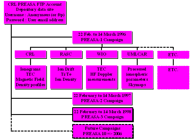
4.1 PREASA FTP data site.
The PREASA database will be housed
at CRL (Kokubunji, Japan) and is accessible through an anonymous FTP account.
In using the account researchers have access to all the data contained
within the PREASA data base, however we urge all researchers to contact
the Principal Investigators responsible for the data of interest and verify
that proper processing and interpretation of the results was done, and
that the correct acknowledgments are supplied with any publication.
In order to facilitate in doing this several procedures need to be followed
by the PREASA participant that is supplying data.
4.11 PREASA data base structure.
Chart 3 shows the general outline of
the PREASA data base. The structure is simple, after logging into the anonymous
account the PREASA main directory is shown. In this directory a list of
sub-directories are supplied. Each sub-directory is titled with the identification
acronym for each of the institutions involved with the PREASA campaign.
The CRL sub-directory will house the data collected by the Communication
Research Laboratory during the PREASA campaign. The WIO directory will
house the data collected by the Wuhan Ionospheric Observatory and so on.
A list of the institutions and contacts are given in section 3.0. Each
institution is responsible for maintaining their own directories.
Chart 3 PREASA database architecture
Each institution sub-directory will have two other lower sub-directories. The first labeled "Unprocessed" will contain, as the name implies, data that requires further processing before being considered valid for general distribution. If the participant can process the data and provide it in final form please do so. However the coordinators of the PREASA campaign are well aware that funding may not permit certain institutions from doing further post-processing that some data sets require. This sub-directory is designed as a deposit site for any or all unprocessed data measurements made during the campaign. If the researcher has data that generally requires further processing, however time or funding do not allow this to be done, please deposit this data into this account. Chances are that other researchers that desperately require a specific data set will contact the institution and inquire on how to further process the data so that they can use it in their analysis. In this way the data is available and will be processed sooner or later. The first rule of any data base is that the data exist in the first place. The institution must supply a documentation text file that identifies the station where the measurements were made, describes the data set supplied and gives a brief description of the format and what type of post processing is required. An example of such a documentation file can be given as;
Example of Documentation Text file for Unprocessed data directoryText File DGS-Skymap.doc
File Description         This text file describes the data set contained within the PREASA database
                               directory labeled PREASA/UMLCAR/Unprocessed.
Institution:                UMLCAR
                              "University of Massachusetts Lowell Center for Atmospheric Research"
                               600 Suffolk Street, Lowell, MA 01854, USA
Contact : Bodo Reinisch
Station Location :      Kokubunji Latitude 35.71N Longitude 139.49E
Instrument :              Digisonde-256
Data ID :                   KO96055.SKY          This file contains skymap data. This data identifies the
                                                               location of reflection surfaces in the ionosphere from
                                                               Digisonde measurements made at Kokubunji on day 55 1996.
                                                               A description of this data file format is given in the documentation
                                                               file labeled FORMAT.SKY  in this directory. Executable programs
                                                               are given in this directory labeled RDODDA.EXE to read and
                                                               extract information in a flat file system.
Level of Process :     Intermediate step ; This data set has been partially processed to extract the
                               Skymap data set from the raw drift data. However further processing is required.
Further Process :     The skymap data requires further processing by the DDA (Digisonde Drift
                               Analysis) package to supply the apparent velocity vectors. The DDAProgram
                               is complicated to run, please contact UMLCAR and we can assist you in
                               further processing this dataset.
In the example above most of the information necessary to identify the institution and the contact person is given. The Data ID line can contain multiple entries to describe all data sets in the directory. The last two entries specify if any processing of the data was done and what further processing is required. In many cases further processing of the data may required the expertise of the institution data analyst. Or may only require minor modifications. In any event please specify any package used in the data analysis and indicate what further work needs to be done. This text file took less than 10 minutes to generate and can help other researchers quickly identify your data set and how to use it, or who to contact.
The second level in the institution directory labeled "Archive" will house processed data, i.e. data sets that require no more processing and are ready to be supplied to the general community. The data sets in the archived directories will finally be stored on the CRL main database system that will be available for distribution to the general scientific community. In this Archive directory another documentation file similar to that shown above should be supplied, however only the format of the file, what packages were used to process the data and a list of acknowledgments need be attached. An example of the Archive documentation file can be given as ;
Example of Documentation Text file for "Archive" data directory
Text File DGS-Velocity.doc
File Description :         This text file describes the data set contained within the PREASA database
                                  directory labeled PREASA/UMLCAR/Unprocessed/Archive
Institution :                  UMLCAR
                                 "University of Massachusetts Lowell Center for Atmospheric Research"
                                  600 Suffolk Street, Lowell, MA 01854, USA
Contact : Bodo Reinisch
Station Location :         Kokubunji Latitude 35.71N Longitude 139.49E
Instrument :                 Digisonde-256
Acknowledgments:       Using this data set for publication purposes please attached the following
                                   paragraph to the acknowledgment list.
                                  The Digisonde data set used in this analysis was processed and supplied by
                                  UMLCAR under contracts XXXXXXX in cooperation with CRL.

Data ID :                     KO96055.VEL           This file contains apparent velocity data. The data
                                                                  is supplied in ASCII text flat file structure. The format
                                                                  of the file is as follows;
                                 The first three rows contain the Header information
                                                                   Row 1 = Station Name.
                                                                   Row 2 = Latitude, Longitude.
                                                                   Row 3 = Date of observation.
                                 The rest of the data in columns is identified as;
                                                                   Column 1 = Decimal time in UT
                                                                   Column 2 = Vertical Apparent Velocity vector component (Vz).
                                                                   Column 3 = Error in Vz
                                                                   Column 4 = Horizontal Magnetic North-South apparent velocity
                                                                                     vector component (Vns).
                                                                   Column 5 = Error in Vns.
                                                                   Column 6 = Horizontal Magnetic East-West apparent velocity
                                                                                     vector component (Vew).
                                                                   Column 7 = Error in Vew
In the example above a full description of the format of the data file is given. The format is as simple as possible. A flat file ASCII text format in column form is used. Many of the plotting packages currently in use are able to quickly read this format and assign any column to an X, Y and Z coordinate axis. For most researchers it is easiest to retain their own formats. This is fine as long as a complete format description is given or an access routine is supplied that can be used by other researchers. However keep in mind that the format should be kept as simple as possible for both ingest and retrieval. Do not use binary form unless the volume dictates it. If possible, use a flat file structure (which is easy to interpret). The PREASA database is purely for the archiving and retrieving of data. Display packages are not supported, this allows the database to be virtually machine independent. Any display packages an institute feels can aid the researcher in further observing the data can be provided, however it is up to the researcher interested in a specific data set to contact the institution via email and discuss hardware issues.
4.12 Accessing the PREASA data base CRL FTP site
The following commands use the File Transfer Protocols "FTP". If not familiar with FTP the researcher should contact the communications administrator at their institution and ask them about FTP. Most computer facilities are supplied with FTP help and services. The following commands will lead the researcher through a typical FTP connection session. The comments in "< >" brackets indicate keyboard functions, the "[ ]" brackets show the response of the computer, while the comments in "( )" brackets describe what the specific command line does;
(Logging on to the CRL FTP site)
ftp kok_1st_process.crl.go.jp <Enter> (This is the CRL FTP address for the PREASA database)[ 220 kok_1st_process FTP server (Sun OS 4.1) ready.
[331 Guest login ok, send ident as
password.
Password:] (user email address) <Enter>
[230 Guest login ok, access restrictions only
FTP>] ls <Enter>                                      (This command lists the contents of the current directory)
[200 Port command successful
226 ASCII Transfer Complete]
(To change directory and list the directories in PREASA do the following)
cd preasa <Enter>
ls <Enter>
(The list of directories for each institution as of 13 March 1996 will be listed. Keep changing directories until obtaining the sub-directory level required to input or retrieve data. Typing Help in the FTP environment gives a list of commands that can be used to transfer data files).
Note : many institutions have recently just finished taking observations and will require some time to collect the data sets and transfer these via FTP to CRL. The PREASA data base will take time to become fully established so be patient. Expect delays, and where possible make inquiries as to the status of certain data sets.
4.13 No FTP access available
at institution.
If you have received this document and are listed on the PREASA community list, we have at least established communication links in one form or another with you. The limits of your institution in providing the necessary equipment for research should not limit your ability to contribute, benefit and take an active part in the PREASA data base and community. If email is possible, limit your data sets to small manageable sizes and send them to us, or if possible transfer the data to some type of recording media that can be read at CRL and send larger data volumes by mail. Make sure you communicate with CRL and discuss what hardware you have available and what is compatible. If you require data, send the coordinators a list of data sets required and we will email text files to you. Remember we need to be realistic as to how much data can be transferred to you via email. Keep your request small and they can be handled reasonable well. You may try to limit your analysis to smaller time intervals, rather than asking for the entire 20 day campaign data set of ionosonde foF2 values, if the event you are looking for is contained within a few hours on one day ask for only those few hours.
If Fax, Telephone or normal mail is
the only means by which communication is possible again as above data can
be transferred in smaller volumes via normal mail.
5.0 PREASA Communications
Communication issues are further divided into three sub-topics shown in chart 4, these are;
(a) Real-time access for the tele-communication
industry.
An ongoing effort of the PREASA program
is to present Upper Atmospheric Science in terms that are useful for industry.
Equally as important as understanding the physics of the Upper atmosphere,
is the need to transfer this knowledge to the tele-communication industry.
E.g. the researcher is interested in the mechanism that leads to formation
of those irregularities that cause scintillation's. The results of this
research can be used to predict or help compensate for these effects in
ground to satellite communications.
(b) Continue to implement communication networks for the PARTNERS program. PARTNERS was organized by the Ministry of Posts and Telecommunications (MPT), Communications Research Laboratory (CRL), Space Development Agency of Japan (NASDA), National Institute of Multimedia Education (NIME) of the ministry of education, Tokai university, University of Electro-communications, Tohoku university, and about 30 private organizations. In the PARTNERS project, a temporal satellite communications network via ETS-V satellite was established to conduct experiments such as distance-education, TV conference demonstration, radio wave propagation measurement, computer networking experiments and tele-medicine and tele-consulting. An important role of this project is to not only develop technology, but also develop mutual understanding among Asian-Pacific countries.
(c) Setup a number of workshops for
researchers to get together and discuss their data sets, under each working
group. A mini-workshop was conducted from 10 to 14 March 1996 at CRL. Representatives
from Indonesia, Thailand, Japan and USA exchanged data. The workshop should
also involve invitations to industry to participate and indicate those
common areas where science can contribute.
Chart 4 PREASA Communications
5.0 PREASA community : list of PREASA participants and institutions
| Institute | Contact | Replied | Level of
Participation |
|
| CRL
UMLCAR WIO WIP DGT STX/NSSDC LANL LANL STPL Dartmouth CSPARC RAS SD CSSAR NCU CRIRP DSTO LAPAN RRL RASC CMU KMTL PTC ITB IPS NSYSU La Trobe DAES PL/GPIM Ibaraki U. STE Lab CRL CRL CRL CRL CRL CRL CRL CRL CRL CRL CRL MPT ARIB |
K.Igarashi
B.W.Reinisch W. Weixing S.Gong Y-N Huang D. Bilitza A. Jacobson G. Hoogeveen R.H. Wiens C. Fesen P. Richards G.A. Zherebtsov J-S. Guo Tsai (J-Y Liu) J. Wu B. Ward S. Sarso S. Bae S. Fukao A. Sang-in N. Hemmakorn Vinai Sae-Oui U. Sastrokusmo P. Wilkinson K. C. Yeh P.L. Dyson J. Forbes D. Andersen T. Watanabe T. Ogawa H. Minakoshi H. Kato R. Yamazaki T. Maruyama E. Sagawa K. Nozaki M. Nagayama Y. Makita E. Kawai I. Nisimuta Y. Masuda Y. Masuzawa T. Kusama |
Confirmed
Confirmed Confirmed Confirmed Confirmed Confirmed Confirmed Confirmed Confirmed Confirmed Confirmed Confirmed Confirmed Confirmed Confirmed Confirmed Confirmed Confirmed Confirmed Confirmed Confirmed Confirmed Confirmed Confirmed Confirmed Confirmed Confirmed Confirmed Confirmed Confirmed Confirmed Confirmed Confirmed Confirmed Confirmed Confirmed Confirmed Confirmed Confirmed Confirmed Confirmed Confirmed Confirmed |
Active
Active Active Active Active Active Active Active Active Active Active Active Active Active Active Active Active Active Active Active Active Active Active Data Provider Keep informed Keep informed Keep informed Keep informed Keep informed Active Active Active Active Active Keep informed Active Active Active Active Active Active Keep informed Keep informed |
igarashi@crl.go.jp
reinisch@cae.uml.edu wwx@ionos.whcnc.ac.cn gongss@amp.whcnc.ac.cn lunping@noc1.tyc.edu bilitza@nssdca.gsfc.nasa.gov hoog@lanl.gov hoog@lanl.gov rudy@stpl.ists.ca fesen@tides.dartmouth.edu richardsp@csparc.uah.edu root@istmis.irkutsk.su guojszh@sun20.cssar.ac.cn lctsai@csrsr.ncu.edu.tw CRIRP@mimi.cnc.ac.cn wardbd@hfrd.srl.dsto.defense.gov.au Fax: +62-22-614998 shbae@cc.rrl.go.kr fukao@kurasc.kyoto-u.ac.jp eneei003@cmu.chiangmai.ac.th narong@telelan.telecom.eng.kmitl.ac.th Fax: +66-76-212729 utoro@radar.ee.itb.ae.id phil@ips.oz.au kcyeh@cc.nsysu.edu.tw P.Dyson@latrobe.edu.au forbes@zeke.colorado.edu danderson@plh.af.mil watanabe@stereo1.env.sci.ibaraki.ac.jp ogawa@stelab.nagoya-u.ac.jp minakosh@crl.go.jp hisa@crl.go.jp ry@crl.go.jp tmaru@crl.go.jp esagawa@crl.go.jp nozaki@crl.go.jp nagayama@crl.go.jp makita@crl.go.jp kawai@crl.go.jp yamagawa@crl.go.jp masuda@crl.go.jp y-masuza@mpt.go.jp Fax: +81-3-3592-1103 |
The PREASA program was designed to collect and establish a data set from instruments that continuously monitor the atmosphere. The campaign periods from 22 February to 13 March was selected to concentrate efforts in developing a PREASA data base which can be used to achieve a better understanding of the Pacific/South-East Asian dynamics controlling the equatorial anomaly, and to promote communications and collaboration efforts for the ionospheric community in the region. The campaigns have started during solar minimum, and plans are being devised to continue these efforts right through a solar cycle (a life span of at least 10 years). This would allow the PREASA community the ability to monitor and understand the equatorial anomaly region as the dynamics become more complicated with increasing solar activity, causing increased problems for telecommunication systems. The PREASA program is an important step in establishing ionospheric initiatives in this region. The South-East Asian region has its own unique characteristics which must be understood in order for global models to correctly describe the state of the atmosphere in this region.
The efforts of the PREASA community
over the next few months is to establish the database at CRL and address
the issues specified under the working group initiatives presented in this
document. The next campaign period (PREASA - 2) is scheduled to commence
from 22 February to 13 March 1997. The coordinators would like to thank
the PREASA community participants for their inputs and support, and hope
that the next few months result in productive analysis, data exchange and
discussions to help improve the understanding of the physics on the equatorial
anomaly region in the south-east Asian region. We would like to extend
our gratitude to the Ministry of Posts and Telecommunications, the Science
and Technology Agency, and UMLCAR for supporting PREASA.
7.0 References
Appleton , E.V., " Two Anomalies in the ionosphere", Nature, Vol. 157, p 691, 1946
Balan, N. and Bailey, G.J., " Equatorial Plasma fountain and its effects: Possibility of an additional layer.", J. Geophys. res., Vol. 100, No A11, p21,421, 1995.
Fejer, B.G., E.R. de Paula, S.A. Gonzales, and R.F. Woodman, " Average vertical and zonal F region plasma drifts over Jicamarca.", J. Geophys. Res., Vol. 96, p. 13,901, 1991.
Fejer, B.G., " F-region plasma drifts over Arecibo: Solar cycle, seasonal, and magnetic activity effects." J. Geophys. Res., Vol. 98, p. 13,645, 1993.
Kelly, M.C., " The Earths Ionosphere. Plasma Physics and electrodynamics", Academic Press. Inc., London, 1989.
Klobuchar, J.A., D.N. Andersen and P.H. Doherty, " Model studies of the latitudinal extent of the equatorial anomaly during equinoctial conditions.", Radio Sci., Vol. 26, No. 4, p. 1025, 1991.
Martyn, D. F., " Theory of height and ionization density changes at the maximum of a Chapman-like region, taking account of ion production, decay, diffusion, and total drift.", Proceedings Cambridge Conference, p 254, Physical Society, London, 1955.
Pingee, J.E., and B.G. Fejer, " On the height variation of the equatorial F region vertical plasma drifts.", J. Geophys. Res., Vol. 92, p. 4763, 1987.
Rao, B.C.N., " The postsunset rise in foF2 in the transition region and its dependence on the postsunset rise in hF in the equatorial region.", J. Grophys. Res., Vol.68, p. 2551, 1963.
Rastogi, R.G., " Collapse of the equatorial ionosphere during the sunrise period." Ann. Geophys., Vol. 88/02, p. 205, 1987.
Takamai, T., W.L. Oliver and S.Fukao, " Interpretations of the evening/morning enhancements of the Equatorial F Region Zonal Electric field.", Proceedings of eighth Int. Symp. on Solar Terr. Physics, Part-1, Sendai, Japan, 1994.
Tascione, T.F., " Introduction to the space environment." Orbit Book Company, Florida, 1988
Townsend, R.E., "Source Book of the Solar-Geophysical Environment.", AFGWC/WSE, Offutt AFB, Neb.", 1982
Walker, G.O., " Longitudinal structure of the F-region equatorial anomaly-a review." J. Atmos. Terr. Phys., Vol.43, No. 8, p. 763, 1981
Walker, G.O., J.H.K. Ma, E. Golton,
" The equatorial ionospheric anomaly in the electron content from solar
minimum to solar maximum for the South East Asia", Ann. Geophys., Vol.
12, p. 195, 1994
In this section a number of figures display some of the observations made during the PREASA-1 campaign period. Much of the content of this data is restricted to the data base which was immediately accessible at CRL, and while these results are only preliminary they offer an insight into some of the scientific objectives specified by PREASA. The following list, offered as an overview for results from the PREASA campaign, describes the various figures supplied and indicates features in the data set which are of scientific interest.
One of the benefits of the PREASA program
was the ability to use the real time online data sets available from the
CRL network of observatories. This data set is the first available results
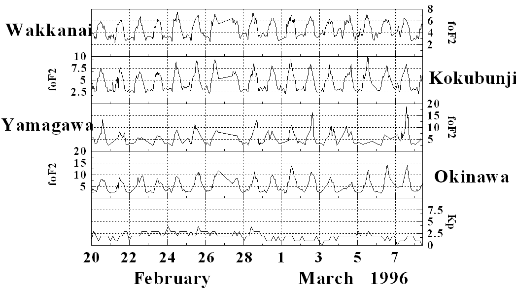
on the PREASA FTP site. In Figure 1, only hourly foF2 values were scaled
from the ionograms recorded at Wakkanai (45.39N, 141.69E), Kokubunji (37.71N,
139.49E), Yamagawa (32.20N, 130.62E) and Okinawa (26.28N, 127.81E). The
foF2 scales are not normalized, otherwise the features at Wakkanai would
be obscured. Note that 3 hourly Kp values are also given. Even though Kp
remains low through out the campaign period substantial differences in
the diurnal variation of foF2 at all stations is observed. Features such
as the enhanced nighttime increase around 4 March 1996 in Wakkanai, is
followed by smallest daytime foF2 values measured at Okinawa for the entire
campaign period. The line between 26 to 28 February 1996 at all stations
is loss of data. Please ignore this feature of the plots.
Figure 1 CRL Ionosonde results
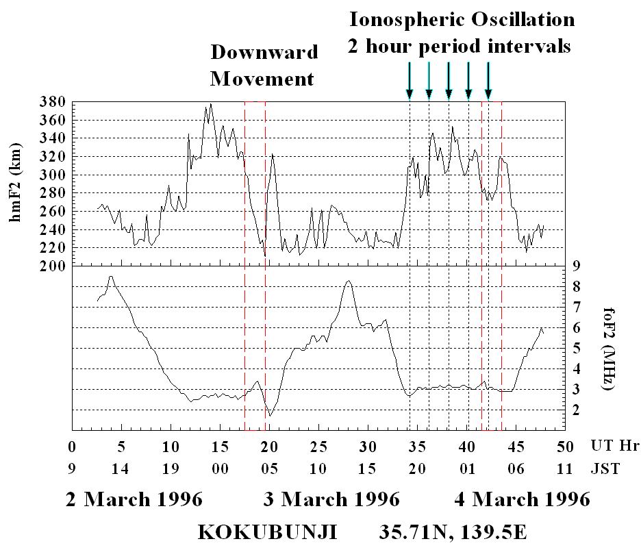
In Figure 2 measurements made with the Kokubunji Digisonde, around 4 March 1996 show a two hour period oscillation movement in the ionosphere that competes with the normal pre-sunrise downward movement typically observed at Kokubunji. The result is that the ionosphere does not move to low altitudes as on the previous night, and no substantial fall in foF2 before sunrise is observe.
Please Note:(a) The red dashed lines specify the beginning and end times when the normal downward motion is observed at Kokubunji. It is not known if the forcing on the ionosphere to low latitudes is due to neutral wind dynamics or ExB downward drift. However its effect is to lower the ionosphere to altitudes where recombination is large and eventually ionization is removed more effectively and foF2 values decrease to low values before sunrise.
(b) The arrows and black dashed lines signify those times when the phase of the 2 hour oscillation (similar to a TID) is causing the ionosphere to move upwards. The fifth arrow at around 42 UT indicated that the oscillation is opposing the normal downward motion of the ionosphere at this time. The ionosphere does not fall to low altitudes as was observed on the previous day, and foF2 in maintained until sunrise.
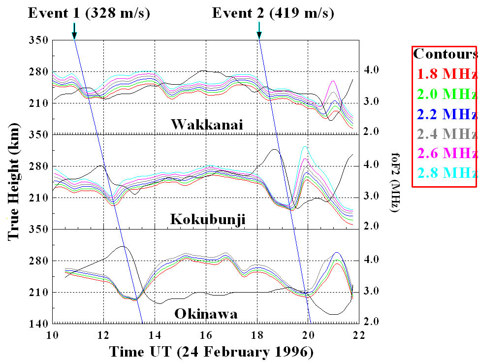
In Figure 3 latitudinal coupling at the Wakkanai, Kokubunji and Okinawa show two separate events. Event 2 is frequently observed throughout the campaign period, however Event 1 was only clearly identified on the 24 February 1996. Due to the progression with time from Wakkanai to Kokubunji, the first explanation was that this effect was due to the propagation of a TID to lower latitudes. Hence the velocity estimates are only given as an indication as to the speed of the assumed TID.
On further analysis, and the fact that Event 1 and Event 2 display similar properties, the latest theory is that this effect is due to processes in the fountain region above the equator. The phenomena causing this effect must originate at high altitudes and move to lower altitudes. This would explain the effect being observed at Wakkanai first, and last at Okinawa. It would also help to explain the increased effect observed in the lower latitudes at the crest of the equatorial anomaly region.
Note : the black lines in each plot are the foF2 values, while all other colored lines indicate the iso-density contour surface and are labeled by the color code on the right of the plot. This type of true height analysis is automatically offered by the Digisonde online true height inversion technique.
The Second PREASA campaign is scheduled
to run from 22 February to 14 March 1997. This period is of particular
interest since it coincides with the total solar eclipse occurring of 9
March 1996 in the China/Russian sector.
The Third PREASA campaign is scheduled
to run from 22 February to 14 March 1998.
The Fourth PREASA campaign is scheduled to run from 22 February to 14 March 1999.
The Fifth PREASA campaign is scheduled
to run from 22 February to 14 March 2000.
The PREASA-6 campaign is running from 22 February to 30 March 2001.
This campaign supports the ongoing efforts of the Post-PARTNERS project (http://www2.crl.go.jp/t/team1/POST/index.html).
The progress achieved in FY 2000 since PREASA-5 is summarized below.
* The Institute of Technology Bandung (ITB), Indonesia was connected to the network.
* New 1.7 GHz beacon receivers for signals from the Japanese Meteorological Satellite were installed at the King Monkut Institute of Technology (KMITL), and at the Chiang Mai University (CMU), Thailand.
* New GPS/GLONASS receivers were installed at KMITL and the Phuket Technical College (PTC), Thailand.
* A new GPS scintillation monitor was installed KMITL.
* A three dimensional presentation system for IRI and PIM models was
developed
in the Multi-Media Virtual Laboratory (http://www2.crl.go.jp/j/mvl/index-e.htm).
* GPS scintillation monitors were prepared for Okinawa, Yamagawa, and
Chichijima Island in cooperation with the Electronic Navigation Research
Institute (ENRI), the Ministry of Land, Infrastructure and Transport
in
Japan. During PREASA-6, the scintillation monitors are collecting data
from 8-30 March.